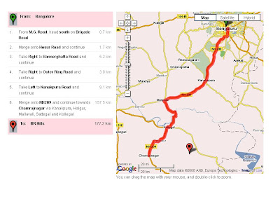
Bangalore -> Kanakpura -> Bluff -> Chamrajnagar-> BR Hills -> Chamrajnagar -> Punjur -> Satyamangalam->Mettupalayam-> Kotagiri->coonoor-> ooty->Masnigudi(Mudumalai)-> Bandipur-> Gundalpet-> Begur->Hediyal->Heggadadevankote-> Nagarhole(National park) -> Heggadadevankote -> Bhimanahalli -> Hunsur -> Kushalnagar -> Mercara -> Somvarpet -> Kenchammana Hoskote -> Sakleshpura -> Hassan -> bellur -> Kunigal -> DodBallapur -> Devaanahalli -> Nandi hills -> Bangalore
The places in bold letters are places of interest and are part of Nilgiris Ranges. We have not decided as yet about, if we would like to do it the other way aroud, As in, instead of going to BR-Hills first we can go to Nandihills and so on.
If we take the clock-wise direction as proposed above in that case, he stoppages would like
Day 1 : 157Km (Bangalore -> Chamrajnagar), with lunch break near Bluff. -> Night stay at Chamrajnagar

Day 2 : BR Hills Climb and back to Chamrajnagar (Bad Roads) -> Total Distance close to 100Km -> We can alse think of going to Punjur and staying there.
A Snap of BR Hills vally :-)

The elevation profile also has to be seen.
Day3 onwards will be worked out later in the blog.
Comments are welcome!
~ Ravi